![]()
![]()
Scope on the Skies
The Hot and Cold of Volcanoes
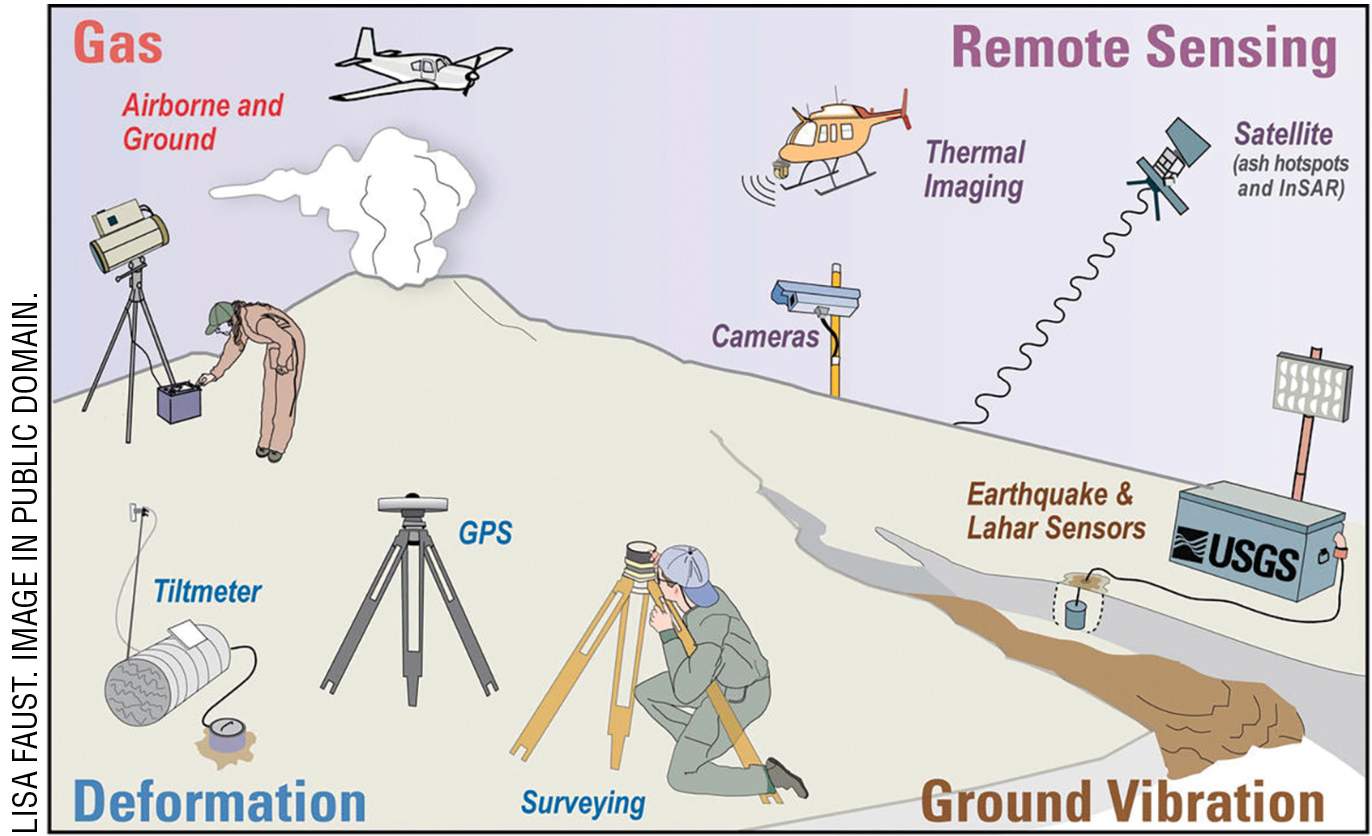
This started out as a column about volcanoes and how a fleet of Earth-observing satellites managed by NASA and other countries’ space organizations are used to monitor volcanic activity and, in some instances, offer predictions based on changes in any observed activity (see Figure 1; also see Online Resources). However, as often is the case when researching for a column, the direction originally planned “veers” off into usually remarkably interesting topics. Volcanoes, as I have been reminded and recently learned, come in a variety of shapes, sizes, locations, and temperatures, and differ in the material that is erupted. Typically, volcanoes are identified as active (currently erupting or undergoing events that may lead to an eruption), as dormant (not active but has erupted within recorded history), or (if there is no record of an eruption) as extinct. However, the term used has little bearing on the volcano, especially when it is based on recorded history because recorded history is not the same length for all parts of the world. In the United States, for example, records of volcanic activity do not extend back into history nearly as far as records of volcanic activity in parts of Europe. There could also be unseen volcanic activity in remote areas or even undersea volcanic activity.
Using modern, improved technology, the history of volcanic activity may be determined through a variety of methods. So, an “active volcano” would be considered as one that has had activity within the last 11,000 years of geologic time (the Holocene Epoch). Volcanic activity is an everyday occurrence somewhere on our planet. To get an idea of volcanic activity on a global scale, go to the Smithsonian Institution Global Volcanism Program website to see a variety of interactive displays of volcanism—including a record of eruptions during the Holocene period as well as a map showing current eruptions (see Online Resources).
Volcanoes on Earth are for the most part associated with the boundaries between crustal plates, typically where oceanic crust interacts with continental crust. Probably the most familiar is referred to as the Ring of Fire, where the Pacific plate is subducted beneath the continental plates of North and South America and eastern Asia. However, volcanic activity may also be at continental spreading centers such as those along the Mid-Atlantic Ridge, as well as within the boundaries of a continent, miles away from the coastline, such as the volcanic activity of Yellowstone National Park. Within the United States there are 12 states having active volcanoes (see Online Resources).
Volcanos form in a variety of shapes and sizes dependent on the composition of the magma and amount of magma reaching the surface. Many of the terms used to describe a volcano and its eruption style are based on the location of a particular volcano. Hawaiian eruptions, for example, have magma flowing out of fissures or the central vent, while Plinian or Vesuvian eruptions, such as Mt. St. Helens or Mt. Pinatubo in the Philippines, are the most violent of volcanic eruptions. Some volcanoes, such as stratovolcano or composite volcanoes, are built up from multiple explosive eruptions of lava flows, ash, and other pyroclastic debris. There are shield volcanoes, like the Hawaiian Islands, which are built up from mostly repeated episodes of lava flows. In a similar fashion, repeated outpouring of lava—but of a thicker composition—may build lava domes.
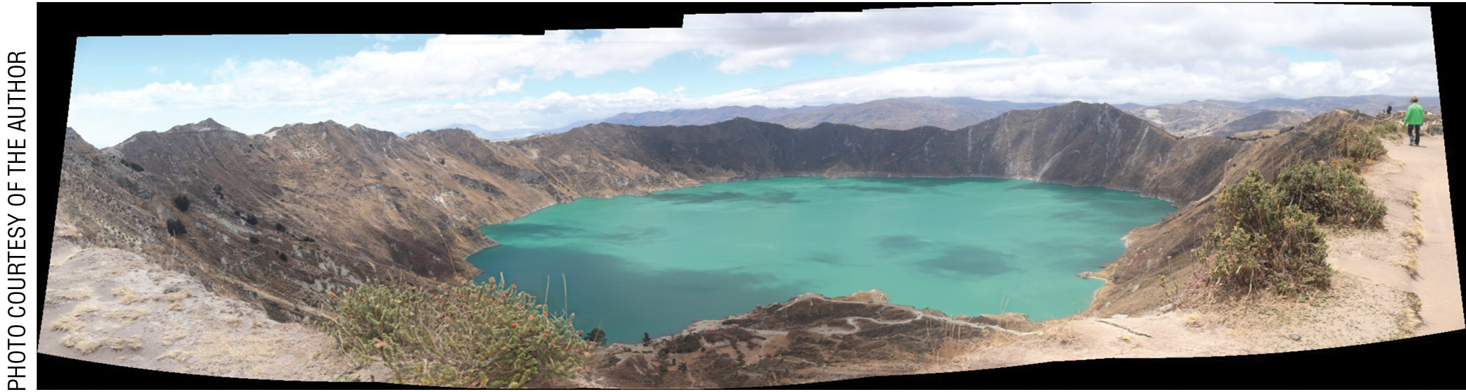
Regardless of the type of volcano, certain features define a volcano or an area that has seen volcanic activity. Cinder cones, like those in Craters of the Moon National Park, form as hot magma is blown high enough into the air for the hot gases and liquids to solidify as they fall back to the ground. Over time, this piles up and forms a cone-shaped mound. Fissure flows of lava happen when the magma flows out of fissures or cracks in the bedrock. Often, after years of weathering and erosion, the remnants of these fissure flows are visible as small mountains or buttes such as those that are seen in Big Bend National Park in southwest Texas. The process of weathering and erosion of a volcano reveals features like dikes, formed from intrusive magma that solidifies and, after weathering, appears as vertical fence-like structures. In some areas all that remains of a volcano is the plug, the mass of magma that solidified within a volcano cone. The remnants of some volcanoes, known as calderas, are filled with water, such as Crater Lake in Oregon and Quilotoa in Ecuador, as well as at several other locations around the world (see Figure 2 and also Online Resources).
Eruptions from a volcano do not always consist of molten rock and gases; however, most eruptions are a result of heat and pressure differences. In many places on Earth, sometimes near oil fields, there are mud volcanoes. These are structures ranging from a few meters to several hundred meters in height and composed of a mixture best described as mud. Subsurface water that is heated and under pressure is forced upward, and as it rises, it mixes with minerals and rocky material forming the mud that eventually reaches the surface (see Online Resources).
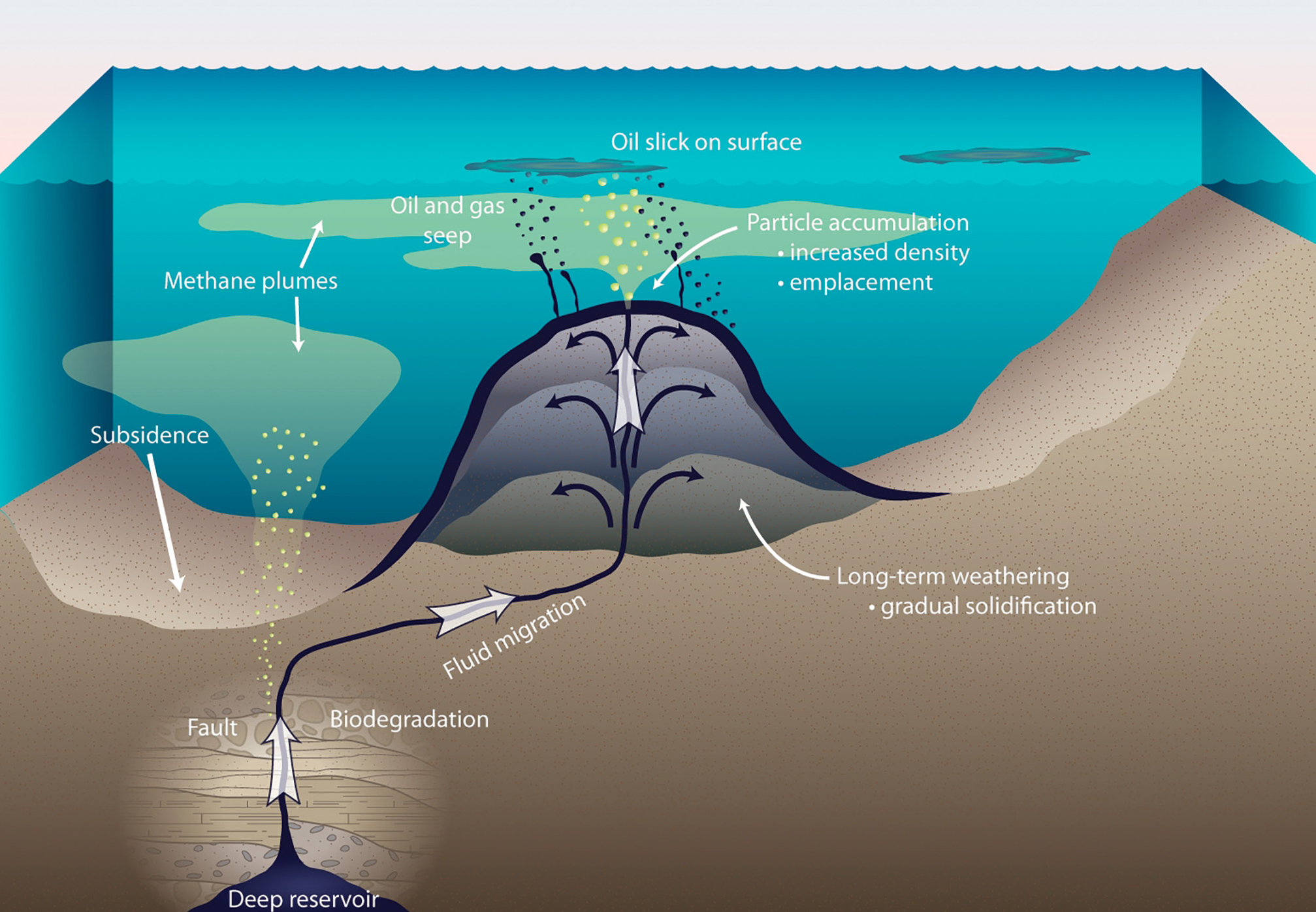
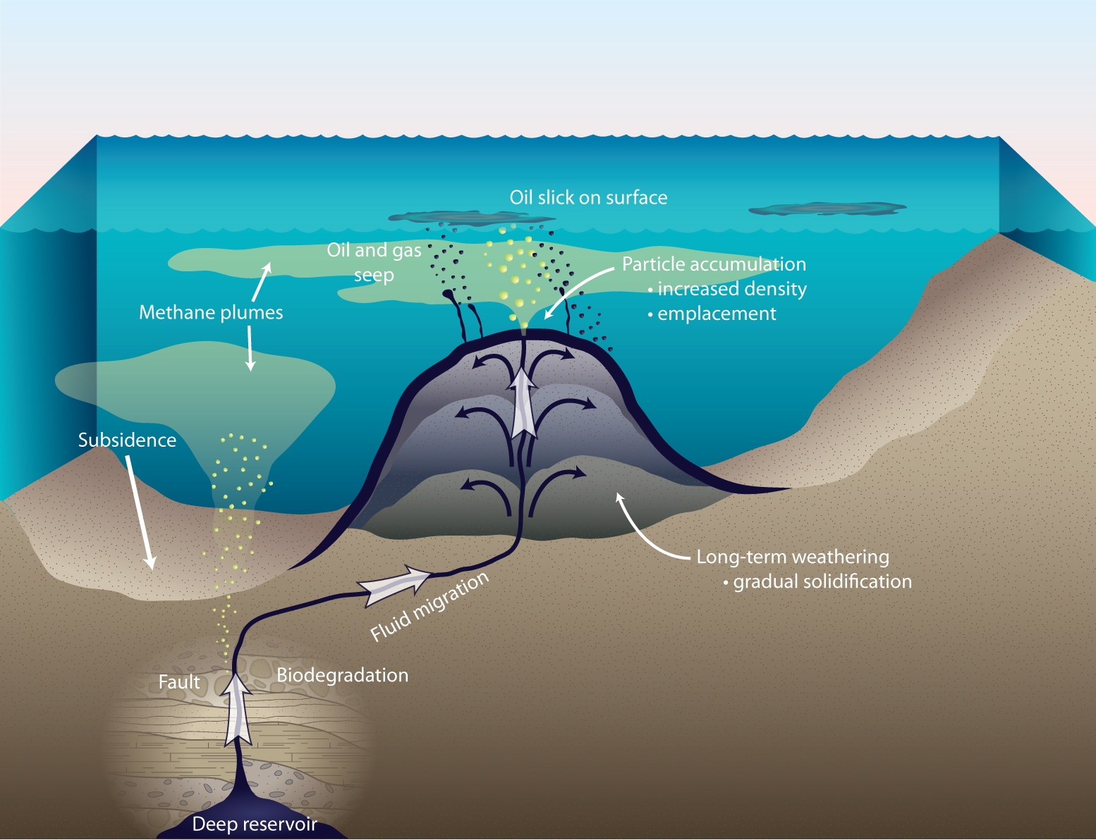
When you hear the word asphalt, what probably comes to mind are roads often called blacktop because they are made from a mixture that includes the black tarry material we know as asphalt. On the other hand, if you have “science teacher humor DNA,” what comes to mind is perhaps some asphalt humor (see Online Resources). An asphalt volcano forms much the way a shield volcano forms, by subsequent outpouring episodes of a tarry viscous material referred to as bitumen (see Figure 3). Asphalt or bitumen is a natural occurring substance and may be found in areas where ancient organic materials accumulated. Over time, these sediments become buried under layers of sediments in ancient lakes and shallow seas. Asphalt may also be found as surface lakes, places where it seeps out of the ground and forms small pools, such as the La Brea Tar Pits in Los Angeles. Pitch Lake, the largest of these asphalt lakes, is located in Trinidad and is about 500 square meters in size and estimated to be 76 meters deep. This lake is not only utilized as a source for asphalt, but it also serves a tourist attraction (see Online Resources).
Another curious type of volcano is known as the ice volcano. Ice volcanoes are not really volcanoes but often form in a cone shape. For an ice volcano to form, moving water (such as from waves) and subfreezing temperatures are required. If conditions are right, a sheet of ice forms on the surface of the water near a shoreline. Because there is wave action, the underlying water can break a hole through the ice, and as the wave action continues, water spurts out of the hole and freezes into a slush that accumulates on and around the hole—eventually forming into a cone shape (see Online Resources).
Exo-Earth volcanoes
Not all volcanoes are located on our planet, and not all volcanoes on other worlds are associated with crustal plate movement or magmatic activity. There is evidence that on at least 10 other worlds in our solar system, there is currently volcanic activity or there has been such activity in the past, however long ago that may have been (see Solar System Volcanoes Infographic in Online Resources). Active hot volcanoes were observed on Jupiter’s Moon Io during the Voyager 1 flyby mission in 1979, and while they were not directly observed erupting, there is evidence for volcanic activity on our Moon, Mercury, Venus, and Mars. The active volcanoes on Io gain their energy from a combined tidal, or gravitational, stress between Jupiter and the moons Ganymede and Europa, thus Io’s volcanoes are driven by external forces. However, lava-spewing volcanos like those on Earth are driven by internal forces such as heat and pressure.
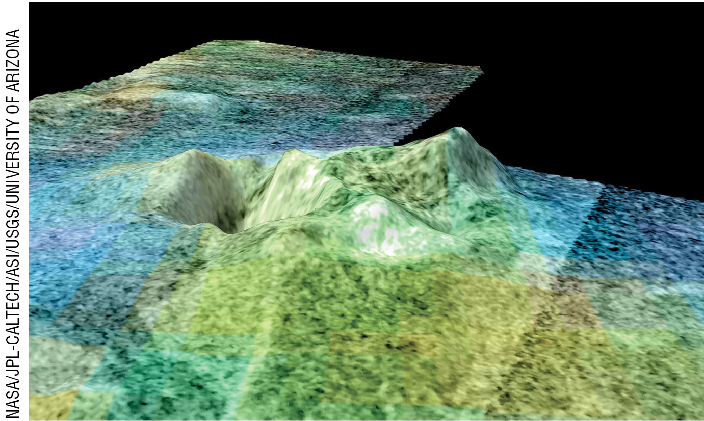
Ice volcanoes, also referred to as cryovolcanoes, have been observed or are suspected to be on several other worlds in our solar system, primarily those moons with an icy surface. It is a fair bet that these cryovolcanoes are not due to wave action as they are on Earth. These cryovolcanoes, however, behave more like lava-spewing volcanoes as they erupt more of a liquid mixture rather than rocky mixture. A cryovolcano requires an icy surface and enough warmth from the interior to maintain liquid below the icy surface. Then, like a water geyser on our planet, a combination of the heat, pressure, and openings in the surface allows bursts of material to reach the surface. The best evidence for cryovolcanoes came from the Cassini mission to Saturn during a flyby of the moon Enceladus when the cameras captured pictures of several fountains, icy plumes of water, ice, and other materials in the erupting mix such as methane and ammonia (see Figure 4). It is also believed that other moons, including Saturn’s Titan, Neptune’s Triton, and even Dwarf Planet Pluto, show evidence of cryovolcanic activity. Recent studies about Jupiter’s moon Europa suggest that below the icy crust is a liquid ocean, and there is a possibility that Europa has enough internal heat to have lava-spewing volcanoes along the ocean floor (see Online Resources).
Volcanic hazards and one named Bob
There are many locations on our planet where volcanoes are near populated areas. So, what is like to be in a volcanic environment, one where there are active volcanoes or an area where the landscape and environment were sculpted from volcanic activity? How about living in an active volcano! Yes, there is a small Japanese town on Aogashima, an island south of Tokyo built within the crater. Apparently, the residents are not terribly concerned because the last eruption was in 1785 (see Online Resources).
Some areas are inherently dangerous given the history of local volcanoes, and there are now, fortunately, the means for being better prepared in the event of a volcanic eruption. From experience we know the power of volcanic events, such as the eruption of Mt. St. Helens and more recently the eruptions of La Soufrière, a volcano on the Caribbean Island of Saint Vincent. The ash cloud and airborne debris blanketed the surrounding islands as observed by NASA Earth Observatory satellites (see Online Resources).
Historically volcanoes have always been a part of human life, and sometimes a volcanic eruption can be both awesome and terrifying at the same time. The USGS maintains a listing of the deadliest volcanic eruptions ranging from the most recent 1999 Mt. Pinatubo in the Philippines to the devastating 79 A.D. eruption of Mount Vesuvius in Italy that destroyed the inhabitants and the city of Pompeii. What was that day, August 24th 79 A.D. like? Watch “A Day in Pompeii,” a 9-minute full-length animated video recreation of that day (see Online Resources).
Two areas on the Earth separated by thousands of miles—New Zealand and Iceland—represent volcanic areas that resulted from the interaction of crustal plates. The volcanic islands of New Zealand, North and South, are both a result of volcanic activity from the subduction of the Pacific Plate under the Indo-Australian Plate, while the volcanic island of Iceland is a result of a rift, or crustal spreading areas, between the North American Plate and the European Plate. Both are situations where there is a seemingly endless supply of magma to fuel the volcanoes. See Online Resources for a link to a short animation of an underwater volcano forming off the New Zealand coast.
In some places an active volcano is easily and safely viewable from a distance and becomes a tourist attraction. In Iceland, there are active volcanoes in various stages of eruption. One such area near the small town of Grindavík overlooks a lava-flooded valley where there are a series of five active volcanoes and cinder cones. Because of the eruptions, this area has become a popular place for viewing.
For an engaging and informative report about volcanoes, join a local Iceland news reporter on the slopes overlooking the valley as he describes the volcanic activity and the valley below it, explaining that the valley was given a name by the locals and that both the valley and volcanoes were for sale. As his reporting continues, volcano number 1, named Bob, starts erupting spewing fountains of lava hundreds of feet into the air (see Online Resources).
For students
1. Download and assemble the paper model of a stratovolcano to help visualize the internal and external structure of that type of volcano.
2. Explore Jupiter’s moon Io at NASA’s interactive website (see Online Resources).
3. Start a volcano watch by linking to websites with current data and webcams (see Volcano Observation Websites after Online Resources).
Don’t Stop Now!
There is a wealth of resources about volcanoes online, and for a good overview of volcanoes refer to the online book Volcanoes. For more information about volcanoes and volcanic activity on other worlds in our solar system, refer to Active Volcanoes of Our Solar System at the Geology.com website (see Online Resources). Also visit NASA’s Space Place Space Volcano Explorer website (see Online Resources). And an internet search on PBS will list several videos about volcanoes. •
Visible Planets
Sky Calendar
Online Resources
30 Years Saving Lives from Volcanoes—www.usgs.gov/news/30-years-saving-lives-volcanoes
A Day in Pompeii—youtu.be/dY_3ggKg0Bc
Build A Paper Volcano (PDF)—bit.ly/3va5drJ
Active Volcanoes of Our Solar System—geology.com/articles/active-volcanoes-solar-system.shtml
‘Apocalyptic’ landscape in aftermath of volcanic eruptions on St Vincent—bbc.in/3pIxK6o
Asphalt Humor—This person walks into a convenient store holding a piece of asphalt and orders 2 sodas. “One for me and one for the road.”
Asphalt Volcano—upload.wikimedia.org/wikipedia/commons/e/ec/Asphalt_volcano2_h.jpg
Big Bend National Park—www.nps.gov/bibe/index.htm
Carl Sagan Day—bit.ly/3iBSU4z
Cold Explosion (Cryovolcanism)—www.nationalgeographic.org/article/cold-explosion/
Crater Lake National Park—www.nps.gov/crla
Craters of the Moon—www.nps.gov/crmo/index.htm
Deadliest Volcanic Eruptions—on.doi.gov/2TURdFb
Explore Io—solarsystem.nasa.gov/moons/jupiter-moons/io/in-depth/
Eruption at La Soufrière—go.nasa.gov/35bnMkG
Europa’s Seafloor Volcanoes—go.nasa.gov/3ziKvZS
Flyover of Sotra Facula, Titan—www.jpl.nasa.gov/images/flyover-of-sotra-facula-titan
Global Volcanism Program—volcano.si.axismaps.io/
Icelandic Volcanoes—adventures.is/information/icelandic-volcanoes/
Iceland Volcano for Sale & a New Name for the Lava Field—bit.ly/2ToXiJF
La Brea Tar Pits—tarpits.org/
Living with a Volcano in Your Backyard (PDF)—bit.ly/3wc1POd
Mud Volcanoes—en.wikipedia.org/wiki/Mud_volcano
NASA Satellites Detect Signs of Volcanic Unrest Years Before Eruptions—go.nasa.gov/3pILBK4
New Zealand Underwater Volcano Animation—https://binged.it/3xjskBF
New Zealand Volcanoes—www.learnz.org.nz/naturalhazards183/bg-standard-f/new-zealand-volcanoes
Pitch Lake, Trinidad—www.richard-seaman.com/Travel/TrinidadAndTobago/Trinidad/PitchLake/
Possible Ice Volcano on Titan—d2pn8kiwq2w21t.cloudfront.net/original_images/jpegPIA13695.jpg
Quilotoa Crater—en.wikipedia.org/wiki/Quilotoa
Ring of Fire graphic—pubs.usgs.gov/gip/dynamic/fire.html
Smithsonian Institution—volcano.si.edu/
Map of Current Eruptions—volcano.si.edu/gvp_currenteruptions.cfm
Town Built Inside an Active Volcano—bit.ly/3whE8Eb
Solar System Volcanoes Infographic—bit.ly/3wfzirh
Space Volcano Explorer—spaceplace.nasa.gov/volcanoes/en/#
States with Active Volcanoes—bit.ly/3gdAx4A
Tracking La Soufrière’s Plume—go.nasa.gov/3gcMlUy
Volcanic monitoring types and methods—on.doi.gov/3gsQB13
Volcanic Crater Lake—en.wikipedia.org/wiki/Volcanic_crater_lake
Volcanoes—pubs.usgs.gov/gip/volc/
What is an Ice Volcano?—bit.ly/3iAnknP
Yellowstone National Park—www.nps.gov/yell/index.htm
Volcano observation websites
30 Years Saving Lives from Volcanoes—www.usgs.gov/news/30-years-saving-lives-volcanoes
Active Volcanoes Around the World Map—www.radar-tracker.com/volcano_eruption/
Alaska Volcano Observatory—www.avo.alaska.edu/activity/
Eruptions, Earthquakes & Emissions—volcano.si.axismaps.io/
Global Volcanism Program—volcano.si.edu/gvp_currenteruptions.cfm
Hawaiian Volcano Observatory—www.usgs.gov/observatories/hawaiian-volcano-observatory
Real Time Volcano Data—www.usgs.gov/products/data-and-tools/real-time-data/volcanoes
Volcano Hazards—www.usgs.gov/natural-hazards/volcano-hazards/
Yellowstone Volcano Observatory—www.usgs.gov/observatories/yellowstone-volcano-observatory
Webcams: Mauna Loa Volcano—www.usgs.gov/volcanoes/mauna-loa/webcams
WorldCam: Volcanoes—worldcam.eu/webcams/category/volcanoes
Bob Riddle (bob-riddle@currentsky.com) is a science educator in Lee’s Summit, Missouri. Visit his astronomy website at https://currentsky.com.
Astronomy Earth & Space Science Physical Science Middle School